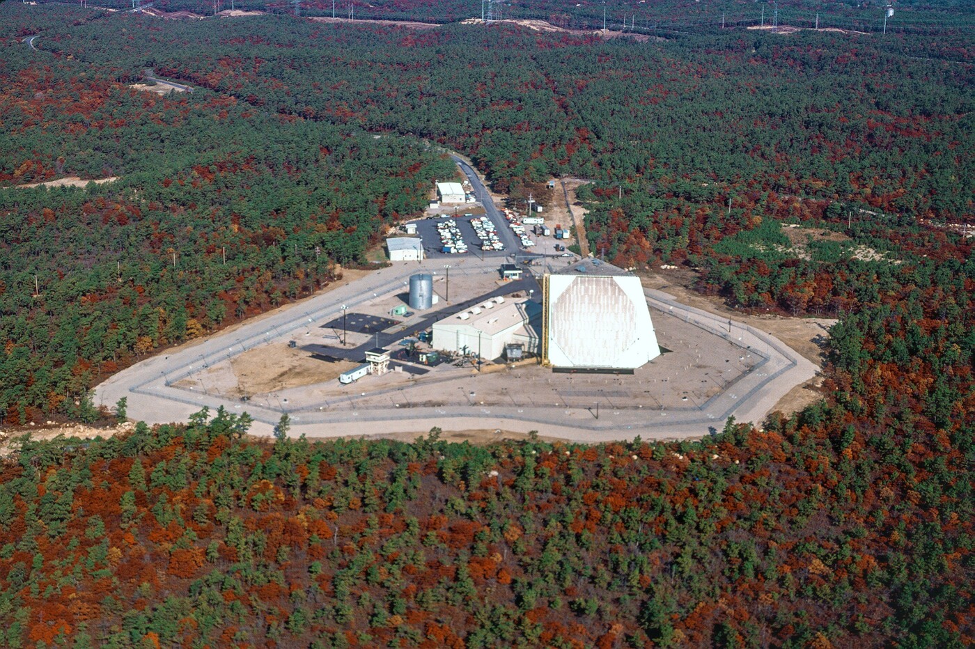
The AN/FPS-115 forms the heart of PAVE PAWS: a long-range early-warning radar built by Raytheon in the late 1970s to detect sea-launched ballistic missiles rising off America's coasts.1 Its reported range is 3,000 nautical miles, roughly 5,600 km.2 It was the first large all-solid-state phased-array radar to enter service anywhere in the world.3 4 name
Watching the sea
By the mid-1970s the nightmare scenario had arrived offshore. A Soviet missile submarine lying off the Atlantic or Pacific coast could fire on a depressed trajectory and put warheads on Washington or Strategic Air Command bases in well under ten minutes, too fast for the northern-facing BMEWS radars built against ICBMs coming over the pole.5 The Air Force's answer began life as SPARS, the SLBM Phased Array Radar System, before its renaming to PAVE PAWS in February 1975.6
The system's first years coincided with the era's most notorious warning scares: the November 1979 and June 1980 false alarms, when training tapes and a failed chip put US forces on alert. The declassified record of those incidents gives a window into the fears and visibility gaps that PAVE PAWS would plug.7
The four sites
The first radar pair covered the two coasts: Cape Cod Air Force Station in Massachusetts reached initial operational capability on April 4th, 1980, watching the Atlantic, and Beale AFB in California followed on August 15th, 1980, watching the Pacific.8 In the mid-1980s an expansion added two southern faces against the Gulf of Mexico approaches: Robins AFB, Georgia (mission operational November 10th, 1986) and Eldorado Air Force Station, Texas (1986–87). The military built the second-pair of radars to an improved standard, often designated AN/FPS-123.9
The southern sites barely outlived the Cold War that justified them. With the Soviet fleet no longer lurking in the Gulf, both shut down in 1995 and entered caretaker status.10
| Element | Value |
|---|---|
| Nomenclature | FPS-115 |
| Manufacturer | Raytheon |
| IEEE Band | UHF |
| Frequency | 420-450 MHz |
| PRF | .02 to 20 Hz |
| Pulse Width | 250 to 16,000 us |
| Rotation Speed | Phased Arrays |
| Power | 600kw Peak (Per Face) 150kw Average |
| Range | 3,000nmi~ |
How it works
Everything before it (BMEWS, the DEW Line's sets) transmitted through vacuum tubes. PAVE PAWS was the first large phased-array radar to go all-solid-state: each building face carries 1,792 active transmit/receive modules (of 2,677 element positions, leaving room for growth), each is a small 340-watt transmitter in its own right.11 The two faces tilt back 20 degrees and each scan 120 degrees of azimuth, giving 240 degrees of coverage from 3 to 85 degrees in elevation, with the beam steered entirely by electronics and zero moving parts.12
The Cape Cod fight
PAVE PAWS may be the only Cold War radar whose loudest battle was with its neighbors. Concern about the beam's health effects on Upper Cape Cod predates the radar switching on: the National Academies reviewed the exposure question in 1979 while the station was still under construction, and roughly 300 people packed a public hearing at Sandwich High School that January.13
The question never quite went away and, to the community's credit, it eventually produced genuine science. A citizens' Public Health Steering Group pushed measurement campaigns and independent review through the 2000s,14 culminating in the National Academies' 2005 assessment: no increase in total or specific cancers because of the radar.15 Beale's neighbors asked the same questions of the western face.16
The move north
Keeping the sites in caretaker status proved wise, with the military able to reuse and relocate pieces from the southern stations.The Clear Radar Upgrade involved trucking arrays from the shuttered sites (chiefly Eldorado's, with a face from Robins by some accounts) to Clear Air Force Station in Alaska, where they replaced the last of the original 1961 BMEWS equipment: the three AN/FPS-50 detection radars and the AN/FPS-92 tracker. The transplanted phased array began 24-hour operations on January 31st, 2001, and reusing the hardware saved roughly $140 million.17
The UEWR era
The radars watching the coasts today are no longer, strictly speaking, FPS-115s. Beale's was the first converted to the AN/FPS-132 Upgraded Early Warning Radar configuration in 2005, joining ballistic missile defense flight tests the following year; Fylingdales followed in 2007, Thule in 2009, and Cape Cod and Clear in 2017–18.18 The UEWRs serve two masters at once: NORAD's Integrated Tactical Warning and Attack Assessment mission, and the Missile Defense Agency's Ground-based Midcourse Defense fire control, which uses their tracks to cue interceptors.19
All three of the US sites operate under Space Delta 4 of the US Space Force: the 6th Space Warning Squadron at Cape Cod, the 7th at Beale, and the 13th at Clear, where Royal Canadian Air Force personnel serve alongside US crews at Cape Cod and Clear under NORAD's binational warning mission.20 Keeping 1980 radars credible isn't cheap (an $866 million sustainment contract covers the six-radar SSPARS family), and at Clear, the Long Range Discrimination Radar that represents the lineage's eventual successor entered service alongside the old array in 2024.21
Taiwan's PAVE PAWS
The family's newest member watches a different sea. Under the Surveillance Radar Program, Raytheon built Taiwan an FPS-115-derived early-warning radar on Leshan mountain in Hsinchu County for roughly US$1.4 billion. First operational in February 2013, it's run by the Republic of China Air Force.22 It gives the island about six minutes of warning against ballistic attack, feeds data both ways across the US-Taiwan relationship, and earned its keep publicly in August 2022 with tracking the PLA's missile salvos during the Pelosi-visit crisis.23
Beale AFB PAVE PAWS Installation
These photographs come from the Historic American Engineering Record survey of the Beale site (HAER No. CA-319), shot by Joseph Scott Murphey around 2000, document the radar in its final years as an original-configuration FPS-115, shortly before the 2005 UEWR conversion. All are Library of Congress public domain.24
Changelog
January 18th, 2026 - An earlier version of this article noted that Thule, Greenland and Fylingdale Moor, England installed FPS-115 radars; this is incorrect. RAF Fylingdales installed a AN/FPS-126 radar between 1989 and 1992 and upgraded to a AN/FPS-132 in 2007 25 . Multiple 26 sources 27 confirm 28 these were installed as upgraded AN/FPS-126 Solid State Phased Array Radar System radars and not the original AN/FPS-115 PAVE PAWS. It appears this inaccuracy has existed online for decades, starting with this brief mention on the RAF website referring to the radar set by the incorrect designation and this UK Heritage page repeating that incorrect information. Because the AN/FPS-126 is upgraded model based on the AN/FPS-11529 , it's possible this caused the confusion. Thule actually received a AN/FPS-120 radar (also based on the FPS-115) 30 . I have also reached out to the RAF media office for firm confirmation. This long update is my attempt to do my part to correct these errors.
Resources
Key references beyond the footnotes above: the HAER No. CA-319, Beale Air Force Base, Perimeter Acquisition Vehicle Entry Phased-Array Warning System (Library of Congress, written report, PDF) (with its LOC record), Hildreth, National Missile Defense and Early Warning Radars (CRS RL30654, 2000) on the early-warning radar fleet's politics, DVIDS, “The 6th Space Warning Squadron: Ever Aware” for the closest thing to a view inside a Missile Warning Operations Center, and DVIDS Cape Cod SFS imagery (2024, public domain) for current UEWR-era photography of Cape Cod. Full source records live in our archive.
Sources & Resources
Websites
- PAVE PAWS Radar System — USSF Fact Sheet Official fact sheet on PAVE PAWS radar system
- PAVE PAWS — Federation of American Scientists Space Policy Project FAS overview of PAVE PAWS capabilities and deployment
- PAVE PAWS — GlobalSecurity.org GlobalSecurity.org reference page
- FPS-115 — FortWiki FortWiki encyclopedia entry on FPS-115
- AN/FPS-115 — Radar Tutorial Technical reference card for AN/FPS-115
Government Reports
- National Missile Defense and Early Warning Radars: Background and Issues Technical reference on national missile defense radars
- Searching the Skies: The Legacy of the United States Cold War Defense Radar Program Comprehensive 1997 USAF history covering PAVE PAWS range and capabilities
Articles
- Air Force eyes upgrades to PAVE PAWS, BMEWS, and PARCS ballistic missile warning radar News coverage of planned radar system upgrades
Archives & Museums
- Historic American Buildings Survey — Beale Air Force Base Library of Congress HABS documentation of Beale AFB
Personal Accounts
- Beale Air Force Tour Notes Personal tour notes from Beale AFB visit
- “FPS-115,” FortWiki; USSF PAVE PAWS fact sheet (archive). ↩
- “AN/FPS-115 PAVE PAWS Radar,” FAS Space Policy Project and “FPS-115,” FortWiki give 3,000 nautical miles; Winkler, Searching the Skies (1997), p. 55 (archive) loosely says “3,000 miles.” ↩
- HAER No. CA-319, Beale Air Force Base, Perimeter Acquisition Vehicle Entry Phased-Array Warning System (Library of Congress, written report, PDF); Eli Brookner, “Phased Arrays and Radars — Past, Present and Future,” Microwave Journal (2006). ↩
- The name PAVE was a US Air Force program prefix, not an acronym; PAWS stands for Phased Array Warning System. The terms “Precision Acquisition Vehicle Entry” (USAF) and “Perimeter Acquisition Vehicle Entry” (used by Winkler, Searching the Skies (1997), p. 55 (archive) and the Library of Congress HAER documentation) applied retrospectively. See “AN/FPS-115 PAVE PAWS Radar,” FAS Space Policy Project. ↩
- Gronlund & Wright, “Depressed Trajectory SLBMs,” Science & Global Security 3 (1992) remains the definitive open analysis of why SLBMs compressed warning time so badly. ↩
- “AN/FPS-115 PAVE PAWS Radar,” FAS Space Policy Project. ↩
- National Security Archive, “False Warnings of Soviet Missile Attacks, 1979–80” (declassified briefing book). ↩
- “AN/FPS-115 PAVE PAWS Radar,” FAS Space Policy Project; “FPS-115,” FortWiki. The 6th Missile Warning Squadron had activated at Cape Cod on October 1st, 1979. ↩
- GlobalSecurity, “PAVE PAWS at Robins”; 9th Space Warning Squadron, Wikipedia; “AN/FPS-115 PAVE PAWS Radar,” FAS Space Policy Project. ↩
- GlobalSecurity, “PAVE PAWS at Robins”; Center for Land Use Interpretation, “Eldorado Air Force Station”. ↩
- “AN/FPS-115 PAVE PAWS Radar,” FAS Space Policy Project; Eli Brookner, “Phased Arrays and Radars — Past, Present and Future,” Microwave Journal (2006); the T/R module design was published as “Solid State Transmit/Receive Module for the PAVE PAWS Phased Array Radar,” IEEE (1975). ↩
- “AN/FPS-115 PAVE PAWS Radar,” FAS Space Policy Project; AN/FPS-115, radartutorial.eu. For an equation-level treatment of range and sensitivity, see George N. Lewis, “Space Surveillance Sensors: The PAVE PAWS and BMEWS Radars” (2012). ↩
- National Research Council, Analysis of the Exposure Levels and Potential Biologic Effects of the PAVE PAWS Radar System (1979); Final EIS, PAVE PAWS Otis AFB (1979, DTIC ADA956473, archived). The Air Force also published measured ground-level intensities: “Radiation Intensity of the PAVE PAWS Radar System” (1979, DTIC ADA072333). ↩
- PAVE PAWS Public Health Steering Group (pavepaws.org, archived). ↩
- National Research Council, An Assessment of Potential Health Effects from Exposure to PAVE PAWS Low-Level Phased-Array Radiofrequency Energy (2005); the public summary is worth quoting. The administrative fight formally closed with the 2009 Record of Decision, PAVE PAWS Cape Cod (2009, DTIC ADA504000). ↩
- Appeal-Democrat, “Beale radar studied”. ↩
- GlobalSecurity, “SSPARS / Clear Radar Upgrade”; 9th Space Warning Squadron, Wikipedia; Clear Space Force Station, Wikipedia. ↩
- CSIS Missile Threat, “Upgraded Early Warning Radar”; MDA UEWR fact sheet. ↩
- MDA UEWR fact sheet; USSF PAVE PAWS fact sheet (archive). ↩
- USSF Space Delta 4 fact sheet; USSF 6th Space Warning Squadron fact sheet; USSF 7th Space Warning Squadron fact sheet; Clear Space Force Station, Wikipedia. The USSF PAVE PAWS fact sheet’s line that “both systems are operated by U.S. and Canadian personnel” appears to be a template artifact: no official source places Canadian crews at Beale. ↩
- Hanscom AFB, “$866M contract sustains 6 missile warning radars” (2018, archived); Lockheed Martin LRDR transition release (2024). ↩
- “A Dossier on the PAVE PAWS Radar Installation on Leshan, Taiwan” (FAS, 2013, archived PDF); Stokes & Lee, Early Warning in the Taiwan Strait (Project 2049, 2022). ↩
- South China Morning Post (2020); Taiwan News, August 5th, 2022. Sustainment continues: Raytheon took a $412.6M Taiwan SRP support contract in 2022: Military & Aerospace Electronics on the Taiwan SRP sustainment contract. ↩
- LOC record; the survey’s HAER No. CA-319, Beale Air Force Base, Perimeter Acquisition Vehicle Entry Phased-Array Warning System (Library of Congress, written report, PDF) runs 57 pages and is the single richest document on the site’s design and construction. ↩
- RAF Equipment page archived in 2012 ↩
- Yorkshire post article on 50th anniversary of RAF Fylingdales ↩
- Visit report from 2002 from Subterranea Britannica ↩
- Interview with Lockheed Martin’s Vice President of Radars and Sensor Systems to ESD in 2023 ↩
- Radar Turorial page on AN/FPS-115 ↩
- TWZ article on Thule capabilities. ↩