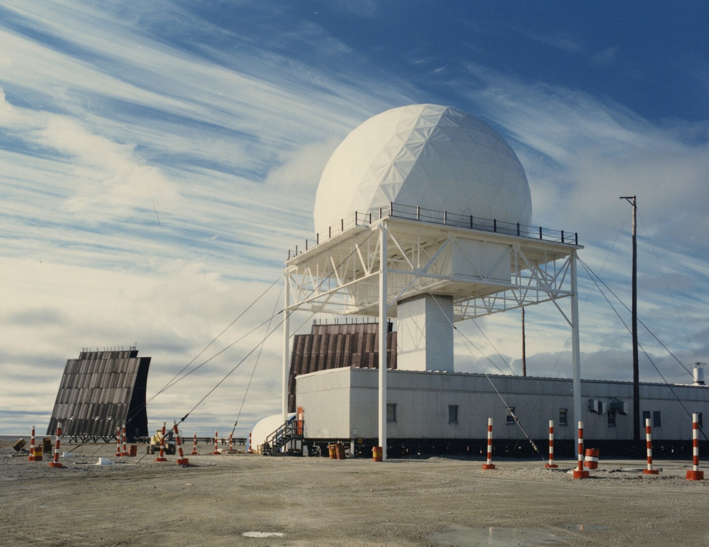
A DEW Line radar installation identified in the NORAD archive as Hall Beach, Northwest Territories — the site of FOX-MAIN — and dated 1986. A white geodesic radome, housing the search-radar antenna, is carried on a tall open-steel tower above a corrugated-metal module building; at left stands a billboard-type tropospheric-scatter reflector antenna. Photographer not recorded in the source file; released to coldwar.tech in a NORAD/USNORTHCOM FOIA disclosure (release MR195346).
Coordinates: 68°45'39"N, 81°13'35"W
FOX-MAIN was one of four Canadian Main stations on the DEW Line, alongside PIN-MAIN (Cape Parry), CAM-MAIN (Cambridge Bay), and DYE-MAIN (Cape Dyer). Serving as FOX Sector headquarters, it is the most extensively documented DEW Line station, thanks largely to former crypto radician Paul Kelley's detailed memoir of his 1960–62 service and the Markham Cheever photographic archive from the construction period.
FOX Sector stations
During the DEW era, FOX-MAIN controlled ten subordinate stations — five auxiliary and five intermediate:
- FOX-1 (Auxiliary) — Rowley Island, Nunavut
- FOX-2 (Auxiliary) — Longstaff Bluff, Nunavut
- FOX-3 (Auxiliary) — Dewar Lakes, Nunavut
- FOX-4 (Auxiliary) — Cape Hooper, Nunavut
- FOX-5 (Auxiliary) — Broughton Island (Qikiqtarjuaq), Nunavut
- FOX-A (Intermediate) — Bray Island, Nunavut — closed 1963
- FOX-B (Intermediate) — Nudluardjuk Lake, Nunavut — closed 1963
- FOX-C (Intermediate) — Ekalugad Fjord, Nunavut — closed 1963
- FOX-D (Intermediate) — Kivitoo, Nunavut — closed 1963
- FOX-E (Intermediate) — Durban Island, Nunavut — closed 1963
Site layout
The station occupied 2,880 acres on a coastal point forming the easternmost extremity of a broad coastal plain extending from Foxe Basin to Hall Lake, 20 miles to the west. The site sits at approximately 15 feet above sea level — the general area, as one account described it, appeared to be an emerging sea bottom. Module-based construction featured separate electronic and living modules connected by overhead heated walkways.
Climate extremes at the station ranged from −58°F (−50°C) to +74°F (+23°C), with approximately 36 inches of annual snowfall. A one-mile round-trip water haul was maintained year-round.
Radar and communications
FOX-MAIN's radar and communications suite was typical of Main stations but particularly well-documented. Equipment included the AN/FPS-19 L-band search radar in the main radome assembly, 90-foot-tall tropospheric scatter antennas for the DEW Drop communications chain, two 60-foot west-facing lateral antennas, and a 300-foot AA Tower carrying the AN/FPS-23 Doppler gap-filler system. Television and telephone satellite dishes were added in later years.
With the North Warning System transition, the site received an AN/FPS-117 solid-state 3-D radar, which remains operational today.
Operations
FOX-MAIN operated as one of six Main stations on the primary DEW Line, providing sector command and communications hub functions alongside POW-MAIN, BAR-MAIN, PIN-MAIN, CAM-MAIN, and DYE-MAIN. The five intermediate gap-filler sites in the FOX Sector were closed in 1963 when the AN/FPS-23 Doppler detection concept was scaled back across the entire line. Auxiliary stations continued to operate through the NWS transition.
Heritage designation
The FOX-M Air Terminal Building (building B09A, constructed 1960) was designated a Classified Federal Heritage Building on 20 January 2000 and listed on the Canadian Register of Historic Places (registration #3289) on 21 July 2005. It is a one-storey steel-frame structure designed by Lapierre, Litchfield and Partners under Western Electric Company direction. Several other FOX-M buildings — including the Garage (B10A), the Hangar, and the Atwell Dormitory (HAL B02C) — are also recorded on the heritage register.
Community impact
The DEW Line's arrival profoundly reshaped the Ammiturmiut (Inuit) communities near Hall Beach. By 1958, Inuit had gathered in two large new settlements near FOX-MAIN. The government eventually provided housing, a nursing station, and a school (opened 1967, when the community population reached 237). The Qikiqtani Truth Commission documented the significant social transformation of this period. The community of Sanirajak (officially renamed from Hall Beach on 27 February 2020) grew directly around the station's presence.
Transition and current status
DEW Line operations at FOX-MAIN ceased in 1989. The DEW Line was formally inactivated and the NWS officially activated on 15 July 1993 at a hand-over ceremony at Tuktoyaktuk, NWT. Today the site operates as both a Long Range Radar and Logistic Support Site (LRR/LSS), serving as the main support base for NWS stations across the FOX sector.